About a month ago, everyone’s Facebook news feeds were getting clogged with links to maps where people could color in the states that they’ve visited. Checking off states is certainly a cool thing to do. But what about individual counties? Surely that would provide a bit more insight into people’s travel habits — do they take long road trips, or do they generally fly to various destinations and see nearby sights?
Back in 2006 and 2007 (how is that already 7-8 years ago?!) some of my PSU grad school friends and I filled in maps of what counties in the U.S. we’ve visited. I even made a blog post about it in Sep 2007. Here’s what my map looked like back then:
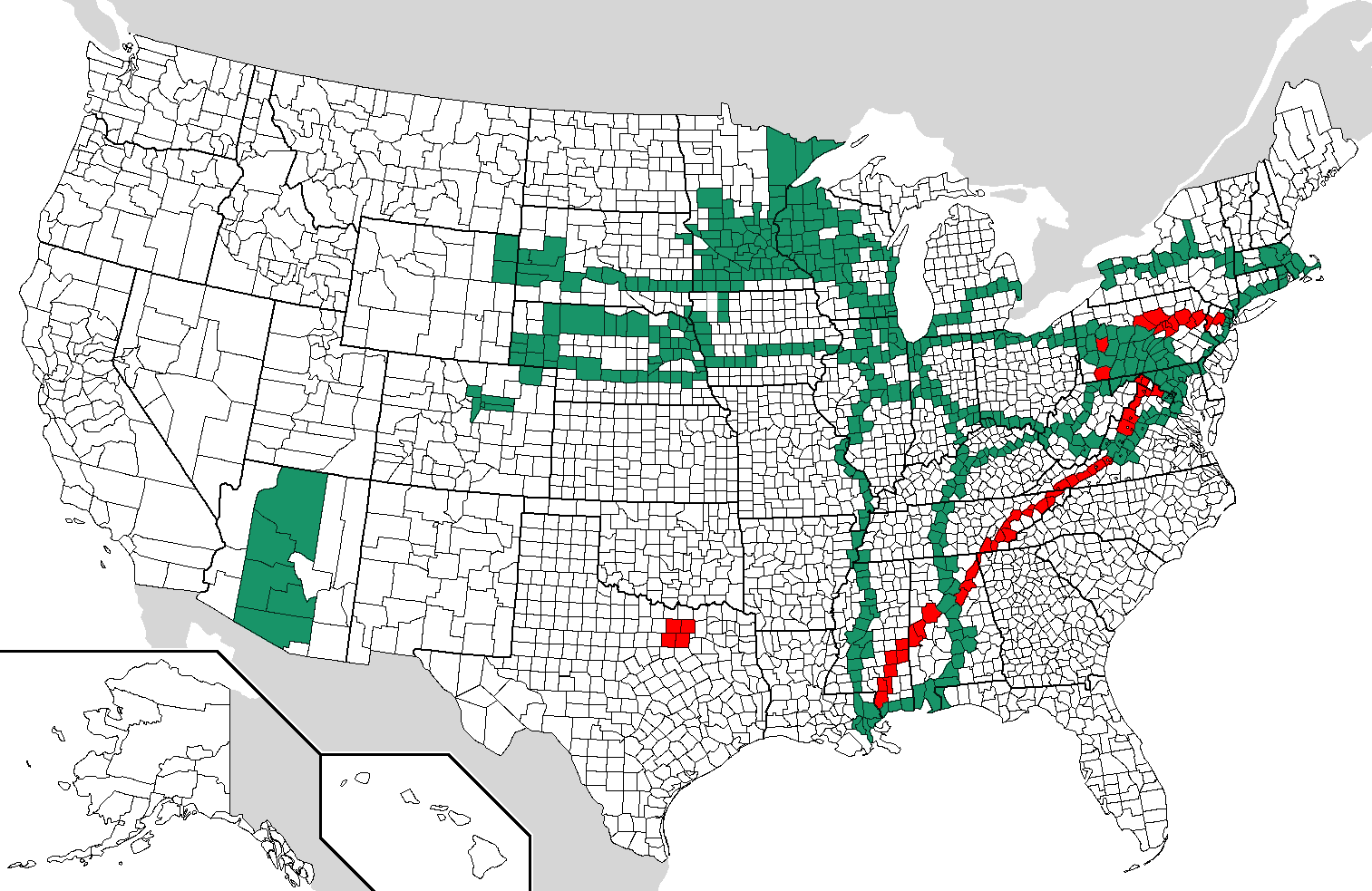 |
The green counties were counties I’d visited prior to fall 2006, and the red counties were new ones I had added by fall 2007. So what does my county map look like now, especially since I’ve lived in two new time zones since I last edited my map? I took the day off from work today (it is the day after Christmas, after all), so I spent my afternoon updating my map. Here’s my current counties visited map:
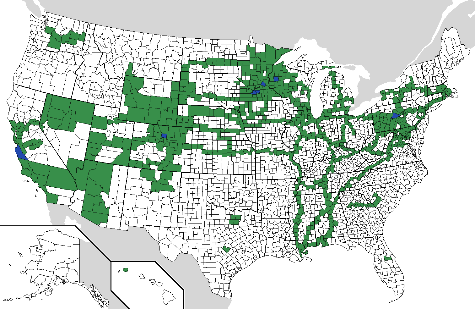 |
The green counties are counties I’ve visited, and blue counties are counties I’ve lived in (Brown, Nicollet, and Hennepin MN, Barron WI, Centre PA, Boulder CO, Monterey CA — Broomfield CO is too small and new to be on this map, unfortunately). I’ve noticed that there are some discrepancies between my new map and my map from 2007 (namely, did my brother Nathan and I follow the Ohio River on the Ohio side or the Kentucky side in summer 2005?, and in what Louisiana parish near New Orleans did my family take an air boat tour of a bayou way back in 1994??), but I’m pretty sure my current map is mostly accurate. I started from scratch today, with my 2013 Rand McNally road atlas as a guide for what roads were in what counties.
Filling in this map was a fun trip down memory lane. I’ve visited counties on all three coasts in the U.S. (Atlantic, Gulf of Mexico, Pacific). Having traveled on nearly every single mile of I-80 from coast to coast (Kimball, NE to Cheyenne, WY is the only missing segment) sure helped me check off a bunch of counties. Several other interstates are clearly visible here as well from various long road trips, as are locations of a few academic conferences I’ve attended, which are disconnected from my other counties (Seattle, Orlando, Dallas, Austin, Atlanta). Clearly I need to fill in more places in the Pacific Northwest/Northern Rockies, Alaska, the Southern Great Plains, the Mid-Atlantic, and New England. And I think I’ll start keeping a separate counties visited map for our baby once he or she is born in late March. 🙂
So what does your county map look like? Download this blank map from Wikipedia (or if that link breaks, try here), and leave a comment!
One Response to U.S. Counties Visited